Ten miles southwest of Flagstaff along Woody Mountain Road, out beyond the Arboretum, lies Rogers Lake. It’s a lake only ephemerally, during springs with heavy snow runoff. At these times, the lake also draws in waterfowl and eagles. More often, and especially this year, Rogers is grassy and wildflowery grazing land for cattle and elk.
Coconino County owns more than 2,000 acres — the Rogers Lake Natural Area — which includes the lake and many acres of forested high ground to the east. Here, the county has developed two splendid trails and a watchable wildlife viewing platform.

Rogers Lake sits at the bottom of a small closed basin, with a drainage area of perhaps 5 square miles. When it fills with water in wet springs, it doesn’t simply evaporate. The story is more complicated and interesting than that, and it’s part of the larger geological story of why Rogers Lake exists as an isolated drainage basin in the first place.
That story began 6 million years ago when the Woody Ridge shield volcano erupted. Not to be confused with the much younger Woody Mountain cinder cone, the shield volcano unloosed an enormous flood of runny basaltic lava. Think of the Kilauea flows you’ve seen recently.
This river of lava poured northward through a narrow valley. The lava couldn’t spill out to the east because the Oak Creek Fault lay to that side. And 6 million years ago, the east side of the fault was upthrown, forming a tall escarpment, one side of the valley. Nor could the lava spread westward, for on that side sedimentary rock of the Moenkopi Formation stood high, the other side of the valley.
The river of lava flowed north for 9 miles until it reached a point where the east valley side was low enough that the flood of lava spilled out, toward today’s Flagstaff. Lava that cooled and solidified along the way now underlies Fort Valley and Cheshire and crops out as the walls of The Narrows alongside the Museum of Northern Arizona. The leading edges of that basalt flow cap today’s McMillan Mesa and Cherry Hill.

Later movement on the Oak Creek Fault raised the west side above the east, as we see it today. Rain and snow falling on the Moenkopi Formation high above the position of today’s Rogers Lake washed downstream toward the east and across the basalt flow. Over time, this stream eroded a narrow valley through the basalt. Today, we drive through this narrow valley along Woody Mountain Road between the Arboretum and Rogers Lake.
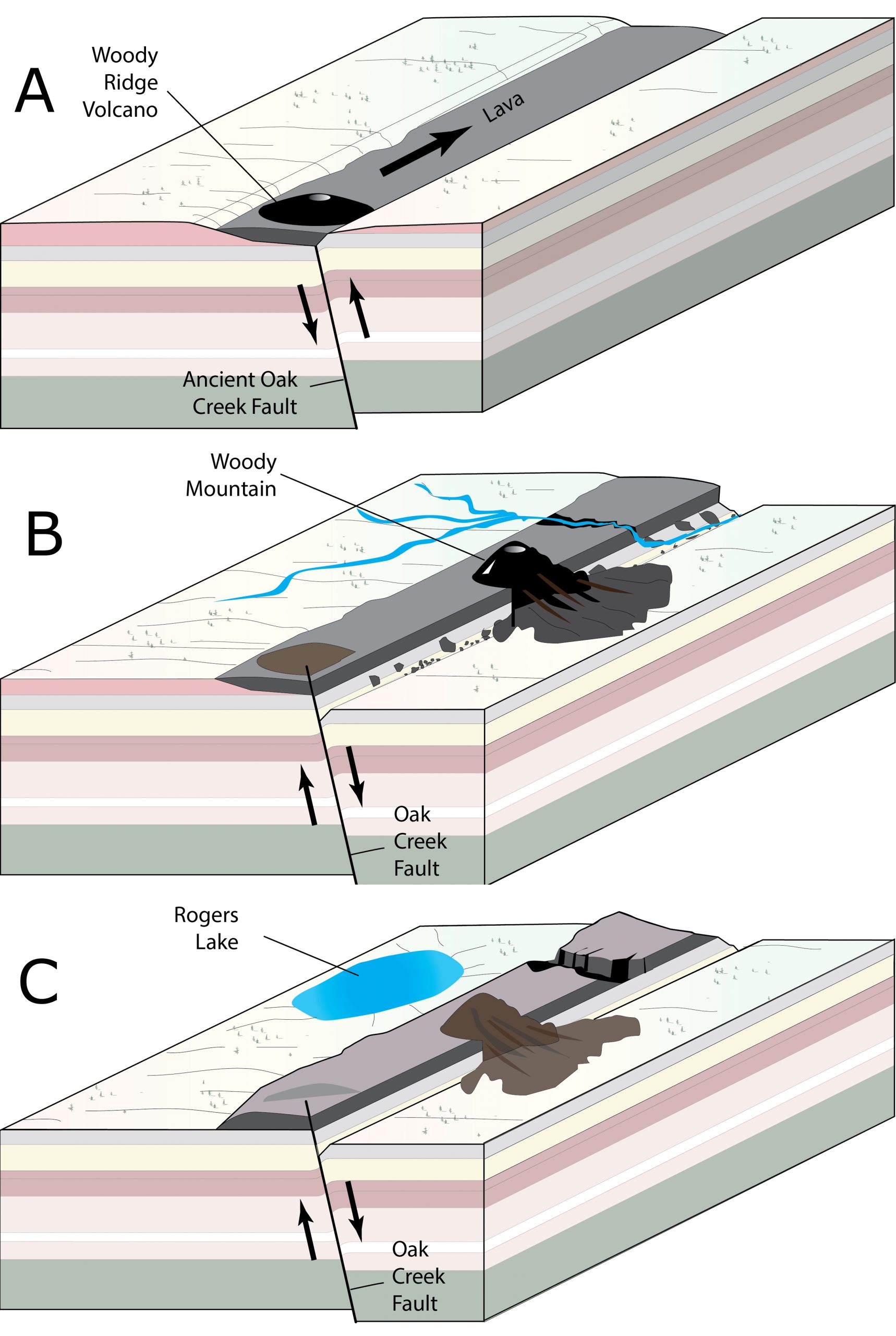
This stream erosion continued for millennia, until eventually, in the vicinity of today’s lake, the streambed was eroded down to the top of the Kaibab Limestone. Rainwater can dissolve limestone, and the stream increasingly drained into the subsurface through sinkholes, caves, and faults. Eventually, the stream no longer flowed eastward across the basalt but settled as a lake, where it sat, slowly seeping into the subsurface. Thus Rogers Lake was born. (A similar drainage capture into the subsurface may explain Mormon Lake’s isolated position, ending an earlier role as the headwaters of Walnut Creek.)
But where does the water of Rogers Lake go, once it soaks into the subsurface? There’s no simple answer. The Lake sits nearly astride two different subsurface dividing lines that separate three directions of subsurface flow: 1) northward toward Blue Spring on the Little Colorado River, 2) eastward toward the Oak Creek Fault, or southwestward toward Geronimo Spring in Sycamore Canyon (and thence to the Verde River).
In the earliest study, Donald Bills and fellow USGS hydrologists voted for northward flow to the Little Colorado; Coconino County hydrologists today favor the interpretation of drainage southwest to Sycamore Canyon and the Verde River. With the additional data today, that does seem most likely.
But if I had my druthers, Rogers Lake’s water would flow eastward in the subsurface to the city of Flagstaff’s Woody Mountain water wells that tap the Oak Creek Fault. Then whenever we drink Flagstaff water, we’d be sipping a soupçon of Rogers Lake. But just like you, I rarely get my druthers!
Want to explore other great water destinations in Arizona? Check out our Celebrate AZ Water archives and choose your next adventure.
This article, which originally appeared on June 28, 2018, is being reprinted with permission. Thanks to AZ Daily Sun for allowing us to repost this article. From time to time, Water – Use It Wisely features guest bloggers who write about topics related to water and water conservation. The author of this blog, Bill Wade is an 11-year National Park Service volunteer ranger. Wade thanks Richard Holm, geology prof emeritus at Northern Arizona University, for challenging and encouraging his interest in Rogers Lake geology, Geoffrey Gross of the Coconino Country Parks and Recreation Department, and Donna Ashworth, whose wonderful history “Biography of a Small Mountain” covered much of this story 26 years ago.