
El Niño is often portrayed as a reliable weather pattern that brings wetter winters to the Southwest. While that has frequently been true in the past, it isn’t guaranteed. Every El Niño develops under different conditions, and this year’s event highlights just how complex these climate patterns can be.
Several oceanic and atmospheric systems are interacting at the same time. Those interactions can strengthen El Niño’s effects, or weaken them entirely. Understanding those moving pieces helps explain why even a Super El Niño doesn’t automatically translate into more rain or snow for Arizona and the Colorado River Basin.
What Is El Niño?
El Niño is a climate pattern that develops over several months in the tropical Pacific Ocean. Scientists identify it by measuring sea surface temperature anomalies, or how much warmer or cooler ocean temperatures are compared to the long-term average, within a region known as Niño 3.4.
Ocean temperatures tell only part of the story. A classic El Niño also requires the atmosphere to respond.
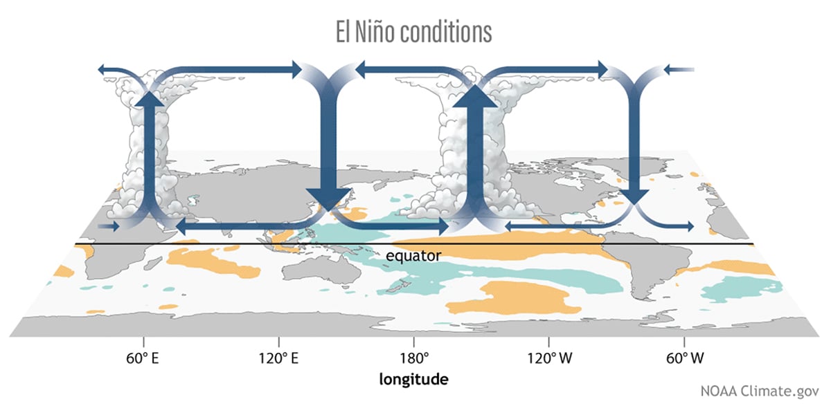
Normally, steady trade winds push warm surface water westward across the equatorial Pacific. During El Niño, those trade winds weaken or even stall. Warm water shifts eastward, and the Walker Circulation, the large-scale pattern of rising and sinking air across the tropical Pacific, moves with it. Together, these changes alter weather patterns around the world.
What Makes This a Super El Niño?
Not every El Niño reaches the same strength.
Scientists classify an event as a Super El Niño when forecast models predict sea surface temperature anomalies greater than +2.0°C in the Niño 3.4 region. These events also tend to develop more rapidly than typical El Niño conditions.
Although stronger events often have greater impacts, their effects still depend on how the atmosphere responds and on what other climate patterns are doing at the same time.
Why Isn’t Every El Niño the Same?
Historically, El Niño has favored wetter winters across the Southwest and warmer, drier conditions across the Pacific Northwest and parts of the northern United States.
However, history doesn’t guarantee future results. This year’s climate is influenced by several additional factors that can either amplify or diminish El Niño’s impact.
Record-Warm Oceans
This year’s El Niño is developing during a period of record-high global ocean temperatures.
In previous decades, the warm waters associated with El Niño stood out more clearly from surrounding ocean temperatures. Today, much of the world’s oceans are already warmer than average, making El Niño’s signal less distinct. As a result, the atmosphere may not respond as strongly as it once did.
Pacific Basin Warming
Scientists have also identified a broader warming trend across the Pacific Ocean known as Pacific Pan-Basin Warming.
Research published in Nature suggests this basin-wide warming has become an increasingly important driver of regional sea surface temperatures during the past decade. When the entire Pacific warms together, the unique fingerprint of El Niño becomes harder to detect, adding another layer of uncertainty to seasonal forecasts.
The Madden-Julian Oscillation
Another important influence is the Madden-Julian Oscillation (MJO).
Unlike El Niño, which remains in place for months, the MJO continuously travels eastward around the globe on a 30- to 60-day cycle.
Its location determines whether it weakens or strengthens El Niño. As the MJO enters the Pacific from the west, it can temporarily suppress the rising air associated with El Niño. Later in its journey, the two systems may align, allowing the MJO to enhance El Niño by increasing heat, moisture, and atmospheric convection over the eastern Pacific.
In other words, the MJO can temporarily turn El Niño’s influence down or up.
Changes in the Polar Vortex
Conditions high above Earth’s surface can also affect winter weather.
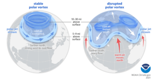
The Polar Vortex is a ring of strong winds that normally circulates around the Arctic in the stratosphere. Occasionally, it weakens and becomes unstable. When that happens, cold Arctic air can spill much farther south than usual.
During January and February 2026, a weakened Polar Vortex pushed unusually cold air into parts of Central America and the southeastern United States. Some of its effects lingered into spring as colder-than-normal temperatures reached portions of the East Coast.
While these events occur far from the Pacific, they can still alter the jet stream and influence storm tracks across North America.
What Does This Mean for the Southwest?
Today’s climate is more complicated than the classic El Niño pattern many people remember.
Warmer global oceans have reduced the contrast that once made El Niño easier to identify. At the same time, climate patterns such as Pacific Pan-Basin Warming, the Madden-Julian Oscillation, and shifts in the Polar Vortex continue to influence the atmosphere in ways that can either reinforce or counteract El Niño.
As a result, even a Super El Niño may not deliver the widespread precipitation the Southwest has historically expected.
What Does This Mean for the Colorado River Basin?
For the Colorado River Basin, the biggest question is whether enough winter storms will produce healthy mountain snowpack.
During periods when the Madden-Julian Oscillation enhances El Niño, the Southwest could experience increased precipitation. However, the combined influence of warmer oceans and other competing climate patterns makes it difficult to predict whether those wetter periods will last long enough to significantly improve snowpack or runoff.
So far, these factors have kept snowpack below average.
While El Niño remains an important climate signal, it no longer acts alone. Understanding how these climate patterns interact is becoming increasingly important as scientists work to forecast water supplies and winter weather across the Southwest.
By Orestes Morfin, Senior Policy Analyst
The Central Arizona Project (CAP) delivers water to nearly 6 million people, more than 80% of the state’s population, in Maricopa, Pinal and Pima counties. CAP carries water from Lake Havasu near Parker to the southern boundary of the San Xavier Indian Reservation southwest of Tucson. It is a 336-mile long system of aqueducts, tunnels, pumping plants and pipelines. The Central Arizona Groundwater Replenishment District (CAGRD) is a special function of the CAP to help water providers and landowners comply with Arizona’s Groundwater Management Act.